
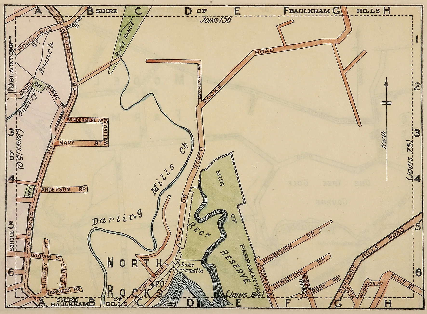
A story of bushrangers, commercial and industrial development, the evolution of transport, and the aftermath of the postwar housing boom.
By Rod Benson
North Rocks Road is one of the principal routes connecting North Parramatta, North Rocks and Carlingford, but its significance reaches well beyond transport. The road extends from the junction of Church Street and Windsor Road in North Parramatta to Pennant Hills Road at Carlingford. From its southern terminus, it runs northward through the Hunts Creek landscape and the suburb of North Rocks before continuing across the higher ground of Carlingford to Pennant Hills Road. The road traverses three modern suburban localities—North Parramatta, North Rocks and Carlingford—rather than lying wholly within the suburb whose name it bears.
Following the higher ground between the ancient water-carved gullies of Darling Mills and Hunts Creek, the road connects a historic, still largely natural rocky landscape with Statham Avenue, the North Rocks industrial and commercial precincts, North Rocks Public School, North Rocks Park and the former Pennant Hills Wireless Station site on the land where Carlingford State High School now stands. Its modern route preserves the historical north–south corridor once known as Governors Arms Road, although nineteenth-century and present alignments do not coincide at every point.
Along and around this course one can trace an unusually rich array of local history: ancient Aboriginal occupation, monumental sandstone formations, colonial roads and mills, bushrangers and illicit stills, orchards and family farms, quarrying, churches, schools, factories, shops, sporting facilities and one of Australia’s pioneering wireless stations. The road itself has changed repeatedly as a rural route became a suburban arterial, yet its course continues to connect landscapes and institutions belonging to very different periods.
To travel North Rocks Road from the Church Street–Windsor Road junction to Pennant Hills Road at Carlingford and on to the Orchard Road shops is to encounter, in compressed form, much of the history of northern Parramatta, North Rocks and southern Carlingford.
An ancient Aboriginal landscape
The history of North Rocks Road begins thousands of years before the road existed. The surrounding country formed part of the lands of Aboriginal people of the Dharug language group, with the Burramattagal particularly associated with the Parramatta district. Sandstone ridges and shelters, wooded valleys and dependable waterways provided fresh water, plants and animals, places of shelter and routes of movement. The modern division of this landscape into suburbs, roads and council boundaries is comparatively recent; Aboriginal occupation was organised around a much older geography of Country, watercourses and ridgelines.
Important physical evidence survives close to the road, particularly around Lake Parramatta and Hunts Creek. Recorded Aboriginal sites include rock shelters, hand stencils, stone-flaking scars and midden deposits. Within the broader Darling Mills Creek system, Bidjigal Reserve contains numerous Aboriginal heritage places, including shelters with art and archaeological deposits. Excavation of the Darling Mills SF2 rock shelter has produced evidence of repeated occupation extending to about 10,000 years before present, making it an unusually early dated Aboriginal occupation site in the Sydney region.
Care is nevertheless required in describing the archaeological evidence. Aboriginal shelters, deposits, art and middens are securely documented within the surrounding sandstone and creek landscape, but this does not justify identifying particular engravings or occupation deposits immediately beside the developed frontage of North Rocks Road unless an archaeological register establishes their location. The road traverses an ancient Aboriginal cultural landscape whose surviving physical traces are most evident where later development has been least intrusive.
Where were the “North Rocks”?
The locality takes its name not simply from a generally rocky landscape but from a conspicuous sandstone formation known to early European settlers as the North Rocks. Historical accounts locate the principal formation around Hunts Creek, where a massive sandstone outcrop terminated a ridge north of Parramatta. The name was therefore originally topographical: these were the prominent rocks lying north of the early settlement.
The locality was also known as Jerusalem or Jerusalem Rocks. Later historical accounts remembered a secluded valley characterised by immense sandstone formations, running water and forest. By the nineteenth century the district had become a destination for excursions from Parramatta. The terminology suggests something much more striking than the scattered sandstone visible in ordinary suburban cuttings today: cliffs, major outcrops, boulders and enclosed valleys were defining features of the landscape.
Whether the original North Rocks could be seen distinctly from central Parramatta has not been established by a surviving contemporary eyewitness description. Their early use as a geographical reference nevertheless demonstrates that the formation was a recognised landmark north of the settlement. Before suburban buildings, road cuttings and altered vegetation transformed the terrain, exposed sandstone ridges would also have been considerably more conspicuous.
The stones that built Parramatta
The geological formation that gave the locality its name did not remain intact. North Rocks sandstone was valued as building material and progressively quarried during the nineteenth century. Local historical sources associate sandstone from the district with Parramatta Gaol, Lake Parramatta Dam and a number of substantial buildings and public works around Parramatta. The disappearance of much of the original outcrop was therefore partly the consequence of the usefulness of the stone itself.
Lake Parramatta Dam provides particularly clear evidence of quarrying within the immediate Hunts Creek landscape. Completed in 1856, the masonry arch dam was an important early Australian engineering work. Quarry sites survive on the hillside above it, demonstrating the direct conversion of local sandstone into civic infrastructure. The dam wall still allows visitors to see how the geology of the district became part of the built fabric of Parramatta.
It is plausible that material derived from the wider geological landscape historically called the North Rocks survives in walls, residences and public buildings throughout the district. That proposition should not, however, be converted into claims about particular stones without supporting evidence. Several quarries operated in the locality, and quarry accounts do not always identify the precise source of individual building materials. What can safely be said is that North Rocks sandstone became an important component of the nineteenth-century built environment.
Two surviving houses on the road provide tangible reminders of this period. Rockcliff at 224 North Rocks Road and Fernleigh at 256 North Rocks Road are recognised heritage properties. Their survival is particularly significant because most of the rural landscape within which such residences originally stood has been absorbed by later residential, institutional and industrial development.
Beauty, bushrangers and byways
The rugged sandstone country possessed several identities at once. It attracted walkers and picnickers from Parramatta, but its caves, thick bush and broken terrain also provided excellent concealment. Between about 1826 and 1830, the country surrounding Hunts Creek and the future Lake Parramatta became associated with bushrangers, including Jack Donohue, John MacNamara and William Underwood. From the creeks, gullies and caves north of Parramatta, bushrangers could hide from authorities and prey upon travellers using nearby roads.
The same geographical qualities encouraged other activities beyond close official supervision. Local histories record illegal distilling in the bushland around North Rocks and Hunts Creek. Joseph Holt, for example, was associated with an illicit still in the wider district in the early nineteenth century. Such activity illustrates how a place could lie geographically close to the colonial centre of Parramatta yet remain difficult to observe and police.
One intriguing physical survival is the old roadway in Bidjigal Reserve traditionally called the “convict road.” A dry-stone wall and surviving road formation are identified by The Hills Shire as part of an early route running approximately parallel to North Rocks Road and probably dating from the 1820s. The traditional name should nevertheless be treated cautiously. The survival of the road is not in question, but documentary proof that it was formally built by convict road gangs has not been located.
This route must also be distinguished from the better-documented historic road on the western side of Lake Parramatta, constructed in 1887 as relief work for unemployed men. That road preserves cobbled surfaces and substantial dry-stone retaining walls. Another early route on the eastern side of the lake has been attributed to the 1850s. The several surviving formations demonstrate that the nineteenth-century road network around Hunts Creek was more complicated than the modern map suggests.
Darling Mills and the beginnings of the Road
The emergence of the road later known as Governors Arms Road was closely associated with Darling Mills. In 1825 the merchant John Raine received land at Parramatta, and in 1826 his steam-powered flour mill commenced operation near the junction of Hunts Creek and Darling Mills Creek. It was notable as a mill that did not depend upon wind or flowing water and was reported to have substantial milling capacity. Farmers north of Parramatta needed access to the mill, giving the developing road corridor a practical economic purpose.
Raine was one of the more colourful entrepreneurs of colonial New South Wales. His business interests included shipping, farming, milling, baking, retailing and transport. At Parramatta he combined the flour mill with a bakery, store and stage-coach service to Sydney. His ambitions proved vulnerable to the severe economic difficulties of the late 1820s, and he was eventually forced to dispose of much of his property. He returned to seafaring and died in 1837 when his ship was wrecked. Raine Avenue retains his name in the modern suburb.
Darling Mills outlived Raine’s ownership and passed through a succession of industrial uses. Flour milling continued under later owners and tenants before the site became associated with tanning, fellmongering, candle manufacture and, from the later nineteenth century, woollen production. The Parramatta and later Sydney Woollen Mills maintained the southern end of the North Rocks Road corridor as an industrial landscape long after its original milling function had disappeared.
Governors Arms Road and Lambert Grange
For much of the nineteenth century the road was known as Governors Arms Road. The name derived from a 300-acre property granted to the merchant Thomas Horton James on 18 June 1840, through which the road passed. James had already acquired Darling Mills in 1833, giving him interests both in land along the road and at its industrial southern end. Governors Arms Road retained its name until it was officially renamed North Rocks Road in 1910.
In 1859 Edwyn Henry Statham purchased 300 acres from Thomas James, including the western portion of what is now Hunts Creek Reserve. Statham established an orchard and lived at a property known as Lambert Grange. This spelling is confirmed by contemporary evidence from Statham’s lifetime, including an 1870 newspaper notice, and should be preferred to the form “Lambert Grove” appearing in some later local histories. His residence stood near the present intersection of Statham Avenue and North Rocks Road, while Statham Avenue originated as his route towards Parramatta.
The identical acreage, transfer from James and geographical relationship with Hunts Creek strongly suggest that Statham’s property substantially represented the former Governors Arms estate. Exact equivalence should not, however, be assumed without cadastral reconstruction. The documentary evidence securely places the estate around the North Rocks Road–Statham Avenue–Hunts Creek landscape, but the boundaries of the 1840 grant cannot yet be reliably translated into a sequence of present-day house numbers.
Statham’s career extended well beyond orcharding. He had been involved in colonial journalism and printing and served as New South Wales Government Printer from 1836 to 1841. He later worked at the Parramatta Lunatic Asylum, including as storekeeper and manager, before settling into the life of a landholder and orchardist at North Rocks. His son Edwyn Joseph Statham became a significant road engineer in the New South Wales public service and later served on the first Baulkham Hills Shire Council. The family thus connected North Rocks with colonial publishing, government administration, engineering and local government as well as agriculture.
Rockcliff, James Burns and Gowan Brae
Another prominent resident associated with North Rocks Road was Sir James Burns, co-founder of the shipping and trading company Burns Philp. By the early twentieth century Burns owned Rockcliff at 224 North Rocks Road and the nearby Gowan Brae estate. His residence in the district connected a semi-rural landscape of orchards and substantial houses with one of Australia’s most important commercial enterprises in the Pacific.
Burns died at Gowan Brae in 1923, but the history of the property after his death was more complicated than a simple transfer to The King’s School. His son James continued there for a period before leaving in 1925, while portions of the wider estate became associated with institutions including Burnside Presbyterian Homes. The King’s School ultimately acquired substantial land in the area and relocated from central Parramatta to its present North Parramatta campus in 1968.
Rockcliff remains important not merely because of its architectural character but because it illustrates a layer of North Rocks society that coexisted with family farms and orchards. Wealthy merchants and professionals could regard the elevated, semi-rural country north of Parramatta as desirable residential land while remaining connected to the economic life of Sydney.
Orchards, farms and family life
Agriculture dominated North Rocks through much of the nineteenth and early twentieth centuries. Citrus orchards were important, as were peaches and nectarines. During the twentieth century agricultural activity diversified into poultry farming, dairying, piggeries, nurseries, cut flowers and other forms of small-scale production. Orchards and poultry farms remained conspicuous features of the locality into the 1950s.
North Rocks Road consequently functioned as a working rural road. Fruit, eggs and other produce moved towards Parramatta and wider Sydney markets, while farmhouses, sheds, poultry yards and orchards lined a route that bears little visual resemblance to the continuous suburban development of the present day.
The Maher family provides a particularly well-documented example. Edward James Maher and his wife Brigid Ellen Porter initially operated a small hotel in Church Street, Parramatta. Edward subsequently acquired the 32-acre Hollister’s Farm at North Rocks and developed an orchard. Edward and Brigid raised fourteen children, demonstrating the scale of household life that could accompany nineteenth-century agricultural enterprise.
A family tragedy resulted in one of the road’s most enduring historical places. Following the accidental death of Edward Maher’s granddaughter Eva Maud in 1888, Maher donated four acres of his property to the Catholic Church for a cemetery. The resulting North Rocks Catholic Cemetery became the burial place of local farming families and members of Catholic religious communities. It remains a direct physical connection between the modern suburban road and the nineteenth-century orchard society that preceded it.
The archival record disproportionately identifies male property owners, but farming was a household economy. Women and children participated in the domestic, agricultural, educational and religious life of these properties, even where their work is less visible in land titles and municipal records. The history of North Rocks orcharding therefore belongs to families and households rather than only to the men whose names appear in formal documents.
City water supply and environmental change
Hunts Creek has repeatedly shaped the history of North Rocks Road. In 1856 its waters were dammed to form Lake Parramatta, creating Parramatta’s municipal water supply. The protection of the catchment had an important long-term consequence: substantial areas of native vegetation survived close to a city that was otherwise expanding rapidly. Parramatta ceased relying on the lake after connection to Sydney’s metropolitan water system in 1909, and recreational use subsequently became increasingly important.
The environmental history of North Rocks is not simply one of progressive destruction. Farming, quarrying, road construction and suburbanisation profoundly altered the sandstone landscape, but substantial bushland survived around Lake Parramatta, Hunts Creek and Bidjigal Reserve. These reserves preserve native vegetation, sandstone formations, waterways and Aboriginal heritage sites that provide a striking contrast with the developed road corridor.
The creek continues to shape modern infrastructure. The North Rocks Road crossing of Hunts Creek was carried for decades by twin culverts installed during the suburban expansion of the 1960s. Their replacement in 2025–26 by a new bridge demonstrates that present-day engineering still has to negotiate the same waterways and topography that shaped colonial movement through the district.
From rural road to suburban artery
The physical transformation of North Rocks Road only occurred on an incremental basis. The exact dates of the sealing, kerbing and guttering of successive sections of the road are unclear. The nineteenth-century Governors Arms Road was a rural route, progressively improved as agricultural, residential and motor traffic increased. It would be misleading to infer a precise paving date merely from the subdivision of adjoining land.
More substantial road reconstruction accompanied postwar suburbanisation. New North Rocks Road was developed during the 1960s as access arrangements changed around new residential subdivisions, including the Lynwood Estate opened in 1965. Bitumen pavement, stormwater drainage, concrete kerbing and guttering, footpaths and improved intersections were introduced progressively rather than through a single road-building program.
The modern road should likewise not be assumed to reproduce the nineteenth-century alignment in every detail. The 1915 Statham Estate subdivision plan records Arms Road, Hunts Creek and Darling Mills Creek before the development of the modern suburban network, while aerial photography from 1943 still shows a predominantly rural landscape around North Rocks Road and Statham Avenue. These sources demonstrate continuity of the broad transport corridor, but not identity between every section of Governors Arms Road and the present carriageway.
North Rocks never acquired its own railway station, a fact that increased the importance of road transport. Buses connected the district with Parramatta, Beecroft, Epping and other railway centres, while increasing private car ownership after the Second World War transformed traffic volumes. A road that had once carried flour-bound wheat and orchard produce increasingly carried commuters, schoolchildren, industrial freight and metropolitan bus services.
The Pennant Hills Wireless Station
Toward the northern terminus of North Rocks Road, where it crosses Pennant Hills Road at Carlingford, one of Sydney’s most extraordinary technological landmarks of the early twentieth century appeared. In 1910, the Commonwealth approved the acquisition of land at this intersection for a major wireless station. Military considerations favoured the inland site because a strategically important communications installation would be less exposed to enemy barrage than one located directly on the coast.
By May 1911, the foundations and great central mast had been erected. Rising 400 feet, or about 122 metres, the mast dominated the surrounding orchard country and could be seen from many kilometres away. Its scale must have presented a startling contrast with the farms and bushland surrounding it.
The Pennant Hills Wireless Station became important in Australia’s developing international communications network. It relayed traffic associated with Douglas Mawson’s Antarctic expedition and assumed particular strategic importance after the outbreak of the First World War. Naval authorities incorporated the installation into Australia’s wartime wireless network, connecting this apparently remote corner of North Rocks and Carlingford with communications circulating around the world.
The later chronology can be stated with some precision. The station closed in 1957, and the great mast was dismantled in 1959. Most of the station buildings subsequently disappeared, although part of the former complex survived in the later St Gerard’s school precinct. The former wireless land became an educational, religious and recreational landscape containing Carlingford High School, Roselea Public School, St Gerard Majella Catholic Primary School and playing fields.
The transformation is striking. Within half a century, land that had been orchard country became the site of nationally significant communications technology and was then redeveloped for schools, churches and suburban recreation.
Postwar suburbia and industrial development
The most rapid transformation of North Rocks occurred during the 1950s and 1960s. Orchards, poultry farms and open land increasingly gave way to houses, streets and institutional development. The relaxation of metropolitan Green Belt restrictions in 1964 accelerated subdivision, while estates such as Lynwood, developed in 1965, signalled the emergence of modern suburban North Rocks.
Industrial development accompanied residential growth. The North Rocks industrial precinct, focused around Loyalty Road and North Rocks Road, eventually covered about 46 hectares and became characterised principally by light industry, warehousing, distribution and vehicle-related activities. Its accessibility to the regional road system helped establish North Rocks Road as a significant employment and freight corridor as well as a residential route.
One of the best-known industrial properties is 219 North Rocks Road, the registered address and Australian head-office location of Unilever Australia. The longstanding association of a major international company with the site illustrates how dramatically the economic geography of North Rocks changed after the orchard era. A road that had served local agriculture became integrated into metropolitan and international corporate networks.
Schools, institutions and the suburban centre
North Rocks Public School, at 359 North Rocks Road, was established in 1923, decades before the suburb’s main period of residential growth. As the postwar population expanded, however, it became one of the defining institutions of the community. Its location on the main road contributed to changing patterns of daily traffic as children, teachers, buses and parents became part of the life of the corridor.
Immediately nearby, the extensive campus of the Royal Institute for Deaf and Blind Children, later NextSense, became another major landmark. Its educational and disability services gave North Rocks Road significance extending far beyond the suburb. The subsequent redevelopment of the site at 361–365 North Rocks Road continues to make this precinct an important focus of planning and community discussion.
The development of North Rocks Shopping Centre, now at 328–336 North Rocks Road, gave the suburb a recognisable commercial centre. Because North Rocks did not grow around a railway station, the concentration of shops, school facilities, institutions and churches along North Rocks Road assumed particular importance. Residents increasingly travelled to the road itself for shopping, education and community activities rather than simply using it as a route to Parramatta or elsewhere.
Farther north, the road continues through the Carlingford locality past the North Rocks Park and Don Moore Community Centre precinct before reaching Pennant Hills Road. This northern section reinforces an important geographical point: the road carries the North Rocks name beyond the modern suburb of North Rocks itself. Its name reflects the historical route and destination rather than a street wholly contained within one suburb.
Churches along the road
The churches along and immediately adjacent to North Rocks Road provide an unusually clear chronology of religious settlement. At its southern end, close to the Church Street–Windsor Road junction in North Parramatta, stands St Monica’s Catholic Church. The foundation stone of its first church was laid in 1888 and the building opened in January 1889; the parish was formally established in 1894. The present church opened in 1960. St Monica’s therefore connects North Rocks Road with the older Catholic history of North Parramatta long before North Rocks itself became a densely settled suburb.
Farther north, North Rocks Community Church at 132–136 North Rocks Road was founded as a Methodist Church in 1957, during the first major phase of postwar residential development. It later became part of the Uniting Church in Australia. Its establishment reflects the broader pattern in which new churches developed alongside Sydney’s expanding suburbs, providing worship, education, youth activities and community networks for new residents. Of particular interest is the fact that two local couples who had been converted to evangelical Christianity at the 1959 Billy Graham Crusade were early leaders of the Church.
The growth of Christ the King Catholic Parish in nearby Statham Avenue can be traced particularly clearly. The parish was formally established on 3 February 1970, and its first Mass was celebrated in the North Rocks Community Centre five days later. A parish census conducted that month identified approximately 1,250 Catholics. Christ the King Primary School began in 1973, and Cardinal James Freeman opened the parish church in August 1974. The church and school complex represents the consolidation of North Rocks as a substantial family suburb.
At the northern end of the road, St Gerard Majella Catholic community developed on the former wireless-station site. The first Mass was celebrated in May 1962 in a hall on the former wireless property, and St Gerard’s became a separate parish in 1963. Church and school development followed, transforming land formerly associated with international radio communication into a centre of worship and education.
More recent decades have brought greater denominational and cultural diversity to the area, including substantial Korean Presbyterian participation. The churches associated with North Rocks Road therefore reflect successive stages of the district’s history: nineteenth-century Parramatta Catholicism, postwar suburban church planting, later institutional consolidation and contemporary multicultural Christianity.
Sport, recreation and open space
Organised sporting life expanded alongside suburban development. Muirfield Golf Club, immediately east of North Rocks Road at Barclay Road, was established in 1953 within a landscape still characterised by orchards and market gardens. Its history offers another example of rural land being transformed into suburban recreational space.
School grounds, North Rocks Park, playing fields and former wireless-station land provided further organised recreation, while Lake Parramatta and the surrounding bushland developed a different recreational identity. By the 1930s Lake Parramatta had become a popular swimming and picnic destination. Walking and conservation later became increasingly important as the surviving bushland acquired greater value within an intensively developed urban region.
There is therefore a long continuity in recreational use, from nineteenth-century excursions to Jerusalem Rocks to modern golf, organised sport, bushwalking and swimming. The same sandstone environment that once attracted early visitors remains one of the district’s principal recreational assets.
Local government, planning and changing boundaries
For much of the twentieth century North Rocks was administered principally by Baulkham Hills Shire, later The Hills Shire. Local government decisions shaped subdivision, roads, drainage, industrial zoning, parks and community facilities. This history explains why significant records concerning North Rocks Road remain divided between the archives and publications of The Hills Shire and the City of Parramatta.
On 12 May 2016, local-government boundary changes transferred most of North Rocks south of the M2 Motorway into the enlarged City of Parramatta. A smaller portion of the suburb north of the motorway remained within The Hills Shire. North Rocks therefore continues to cross a municipal boundary, although the entire Church Street–Pennant Hills Road corridor discussed here passes through the modern localities of North Parramatta, North Rocks and Carlingford.
Planning decisions have repeatedly shaped the road. Relaxation of Green Belt controls facilitated postwar residential development; industrial zoning established the Loyalty Road employment precinct; shopping-centre development produced a new suburban focus; and more recent redevelopment proposals have raised questions about density, traffic, infrastructure and neighbourhood character. The history of North Rocks is consequently not simply a story of inevitable suburban expansion but one shaped by public policy, land values and community response.
A multicultural suburb
The population surrounding North Rocks Road has changed substantially since the first postwar subdivisions. At the 2021 Census, North Rocks had a population of 9,136. Only 54.4 per cent of residents reported speaking only English at home. Mandarin was spoken by 12.4 per cent, Cantonese by 5.8 per cent and Korean by 5.0 per cent, while Chinese was the most frequently nominated ancestry.
Religious affiliation has changed simultaneously. In 2021, 33.0 per cent of North Rocks residents reported no religion, while Catholicism accounted for 22.7 per cent, Anglicanism 10.5 per cent and Presbyterian and Reformed traditions 4.2 per cent. Christianity remained the largest broad religious grouping, but the social setting of the road’s historic churches is considerably more culturally diverse and less uniformly Christian than when many of them were established.
These demographic changes are visible in schools, congregations, businesses and everyday community life. The modern North Rocks Road corridor belongs not merely to a postwar Australian suburb but to a highly diverse metropolitan Sydney.
Crime and public safety
The most distinctive historical association between the road corridor and crime belongs to the bushranging era, when isolation and rugged terrain provided concealment for those evading colonial authorities. Modern North Rocks Road is not unusually crime-prone, although serious offences have occasionally occurred on or adjacent to it.
On 15 July 2026, a man was fatally shot while inside a vehicle on North Rocks Road at Carlingford. New South Wales Police established a State Crime Command homicide investigation, Strike Force Imperon, into the killing. The incident attracted considerable public attention and temporarily disrupted traffic on the road.
The contrast with the bushranging period is instructive but should not be exaggerated. Nineteenth-century road robbery arose partly from geographical isolation and the limited reach of colonial policing; the 2026 homicide occurred within a densely settled metropolitan environment and was investigated as a specific targeted crime. The common geographical setting connects otherwise very different social worlds.
What remains, and what has disappeared
Much of the landscape described in this history has disappeared. The monumental sandstone formation that gave North Rocks its name was substantially quarried. Darling Mills vanished. Governors Arms and Lambert Grange were broken up by subdivision. Most orchards and poultry farms disappeared beneath houses, industrial estates and institutions. The enormous wireless mast that once dominated the northern skyline was dismantled. Aerial photography from 1943 records a rural landscape that became difficult to recognise within only a few decades.
Yet the historical landscape has not been erased. Rockcliff and Fernleigh survive along the road. The North Rocks Catholic Cemetery preserves the names of orchard families. Lake Parramatta Dam and nearby quarry sites retain the history of nineteenth-century engineering and stone extraction. Early road formations survive in and around Lake Parramatta and Bidjigal Reserve. Substantial bushland continues to preserve Aboriginal archaeological evidence, sandstone geology and creek environments largely absent from the developed streetscape.
Street names supply another form of historical memory. Raine Avenue recalls the miller whose enterprise helped give the early road its economic function; Statham Avenue preserves the name of Lambert Grange; other nearby names recall farming families, estate owners and the agricultural landscape replaced by suburban subdivision. Even where buildings and property boundaries have disappeared, the historical geography persists in the map.
North Rocks Road itself may be the most durable artefact of all. Its functions have changed repeatedly, but successive communities continued to use the same broad north–south corridor. Its present geographical extent—from the Church Street–Windsor Road junction in North Parramatta to Pennant Hills Road at Carlingford—crosses three suburban localities and binds together landscapes that are today often thought of separately. It has served Aboriginal Country and creek landscapes, colonial farms and mills, nineteenth-century estates, orchardists and quarrymen, an international wireless station, industrial workplaces, churches, schools, shops, recreational facilities and modern commuter traffic.
To travel North Rocks Road from North Parramatta to Carlingford is therefore to pass through an unusually concentrated history of western Sydney: ancient Country, colonial fringe, agricultural district, technological outpost, industrial and residential suburb, and multicultural metropolitan community. Much of that history is no longer immediately visible, but enough survives in sandstone, bushland, houses, cemeteries, institutional sites, road alignments, street names and community memory to make the past recoverable.
North Rocks Road is far more than a transport corridor: it is a significant cultural artefact in its own right. Its route, surviving buildings, altered alignments, sandstone fabric, churches, schools, cemeteries, industrial sites and adjoining bushland preserve successive layers of human occupation and land use. From ancient Aboriginal presence and the enduring cultural landscape of the Cumberland Plain, through colonial milling, quarrying, orcharding, bushranging and estate development, to wireless communication, suburbanisation, industry and multicultural community life, the road embodies the historical transformation of Sydney’s western and north-western margins. North Rocks Road thus stands as a demonstrative symbol of how landscape, economy, technology, faith, family and migration have combined over time to shape human settlement across the Cumberland Plain and its sandstone fringes.
Further research
Several questions remain open to more detailed primary-source research. The precise boundaries of Thomas Horton James’s 1840 Governors Arms grant and their relationship to Statham’s later Lambert Grange property could be established more confidently by overlaying Crown grant and deposited plans on modern cadastral mapping. Similar work could identify more precisely where the nineteenth-century Governors Arms Road diverged from the present North Rocks Road and New North Rocks Road. Baulkham Hills Shire engineering minutes, annual works programs and subdivision files may also establish when successive sections were formed, metalled, sealed, kerbed and guttered.
Further investigation of quarry accounts could clarify which buildings were supplied from particular North Rocks sandstone workings, while archival research may reveal more about the origins of the Bidjigal “convict road.” Finally, oral histories from long-term residents could preserve memories of the orchards, early buses, wireless mast, small businesses and first decades of suburban development that are only imperfectly represented in official records.
Rev Dr Rod Benson is General Secretary of the NSW Ecumenical Council and a minister of the Uniting Church in Australia serving at North Rocks Community Church in Sydney.
Image source: Scarce miniature c.20th map of North Rocks showing streets and major thorough fares. Collections: National Library Australia: Bib ID: 2127818 (1923 edition) State Library New South Wales: CALL NUMBER: 981.1/W State Library Victoria: SLT 058.944 W69 (1920)

