
By Rod Benson
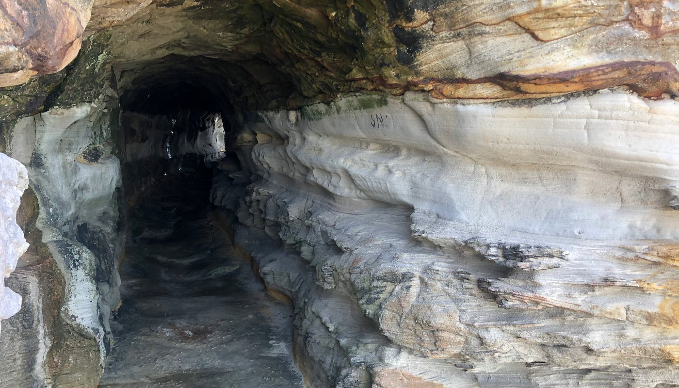
Until last week, I had never heard of the Manly Wormhole. At the northern end of Sydney’s beautiful Queenscliff Beach—the northernmost section of the beachfront commonly called Manly Beach—the smooth sand meets a rockpool at the foot of a rugged headland. Beyond the pool, around an exposed rock platform, a narrow tunnel cuts through the base of Queenscliff Head and emerges above the rocks facing Freshwater Beach. Dark, damp and concealed from casual view, it is commonly known as the Manly Wormhole.
The headland lies on Country associated with the Gayamaygal people, the traditional custodians of this region. Indigenous people inhabited this coastline for countless generations, drawing sustenance, identity and cultural meaning from its lands and waters. The Wormhole is a recent alteration to an ancient coastal cultural landscape.
A secret passage through the cliff
Entering the tunnel from the southern end feels like slipping through a rupture in the headland. The passage curves sufficiently to obscure the entrance as one moves towards the exit. For a few moments there is only rough sandstone, seeping water, an uneven floor and the muffled reverberation of ocean waves crashing against the headland cliffs. Then the northern entrance appears, framing the Pacific like a window.
Published estimates of the tunnel’s length vary. Local historian Richard Michell describes a 25-metre passage, while walking guides and tourism websites commonly give a figure of approximately 40 metres. Without an authoritative survey, its precise length remains uncertain.
The walls bear evidence of deliberate excavation, but the construction method has not been established from contemporary records. Popular descriptions call the tunnel “hand-carved,” while others suggest it was blasted through the sandstone. Neither account has been verified. The passage is also known as the “Queenscliff Tunnel,” a name derived from its location. The term “Manly Wormhole” is a more imaginative popular designation.
Where did “Wormhole” come from?
I have not been able to identify a reference to the “Wormhole” in the early years of the twentieth century. Early references describe a tunnel or pedestrian passage through Queenscliff Point. In modern physics, a wormhole is a hypothetical passage connecting otherwise distant points in spacetime. Physicists Charles Misner and John Wheeler employed the term in a 1957 paper, although Arthur Eddington had used related imagery in 1928. Science fiction later popularised wormholes as portals leading to another place, time or dimension.
The earliest readily verifiable online use located during this investigation occurs in Vanessa Berry’s 2015 essay titled, “Manly, the Worm and the Kangaroo.” Berry calls it “the wormhole” and notes that it is also known as the Queenscliff Tunnel. Her account establishes that the nickname was in use by 2015 but does not identify when or by whom it was coined.[1] By January 2019, Northern Beaches Council was promoting the site as “The Wormhole,” confirming its adoption in public usage. Northern Beaches Council Travel websites, photographers and social-media users have since circulated the expanded name “Manly Wormhole.” The nickname’s precise origin and date remain unknown.[2]
Fishermen, folklore and Robert Lewers
The familiar story is that local fishermen excavated the tunnel in 1908 to avoid climbing over or around the rocks between Manly and Freshwater. Tourism websites, walking guides and Northern Beaches Council have repeated this version. No primary evidence supporting it has been identified in the sources examined.
A different account has been advanced by local historian Richard Michell. He identifies Robert David Lewers—a bank manager who also invested in local property—as responsible for the project. Lewers lived with his family at The Eyrie in Queenscliff, overlooking Manly Beach and the lagoon. His family connections and death in 1911 are independently confirmed by the Australian Dictionary of Biography.[3] Michell reports that Lewers developed the Freshwater Kiosk in 1908 on the rise at the southern end of Freshwater Beach. The building was later incorporated into what is now Pilu at Freshwater. To improve access for visitors coming from Manly, Lewers reportedly commissioned the tunnel as part of a proposed scenic walkway between the beaches.
According to Michell, contractor D. Bevan and his workers completed the tunnel in about three months. By January 1909, the press was reportedly recording substantial pedestrian use. Lewers died in 1911 before the remaining walkway could be completed, leaving the tunnel as the principal surviving element of the project.[4] Michell’s account is detailed, but the underlying newspaper reports, property documents and contractual records are not cited in the published article. Until those primary sources are examined, the Lewers–Bevan account should be identified as a local historian’s reconstruction rather than established conclusively.
The account accords with the district’s documented development. Manly was promoted as a seaside resort, while Freshwater attracted campers and day-trippers. Amos Randell established a collection of holiday huts there known as “Camp City.” Northern Beaches Council Ferries, trams, bathing, camping and commercial ventures were transforming the coastline into an interconnected recreational area.
The fishermen’s account remains part of local folklore, but repetition does not verify it. Current published sources preserve two explanations: excavation by fishermen as a practical shortcut, and construction commissioned by Lewers as part of a scenic route. Only the second identifies a commissioner, contractor and broader project, although its primary evidence remains to be examined.
An unfinished route
During the 1930s, Warringah Council considered a larger road tunnel associated with a northern transport route through Queenscliff. A surviving secondary account is unclear about its relationship to the pedestrian tunnel. The road proposal was abandoned because of its cost and anticipated effect on the landscape.[5]
Photography, travel writing and social media have given the Queenscliff Tunnel wide visibility. Images taken from within the passage show dark sandstone enclosing a bright field of ocean and sky. Although often promoted as a “secret” Sydney destination, its location is now documented by council, tourism and walking websites.
Increased visitation brings responsibilities. Visitors should not carve the sandstone, add graffiti, leave rubbish or disturb marine life. The site is neither a constructed pedestrian path nor a supervised attraction, and its surfaces are exposed to weather, waves and erosion.
Finding the entrance
The usual approach is from Queenscliff Beach. Visitors coming from central Manly walk north along the beachfront through North Steyne to Queenscliff. Queenscliff Rockpool stands at the extreme northern end of the sand, against the southern—or Manly-facing—side of Queenscliff Head.
From the pool, the informal route continues around the exposed rock platform. The entrance is cut into the headland farther around the rocks; it is not beside the pool. The geographical sequence is Manly Beach, North Steyne, Queenscliff Beach, Queenscliff Rockpool, the rock platform and the tunnel through Queenscliff Head. Beyond the tunnel lies the rocky route towards Freshwater Beach.
There is no established public approach from the clifftop, despite what digital maps may suggest, and no formal path across the rocks. Reaching the tunnel requires scrambling over uneven surfaces and is unsuitable for prams, wheelchairs or people unsteady on their feet.
Low tide or shark biscuit
It’s best to approach the site near low tide and in calm conditions. Swell, wind, rain and unexpectedly large waves may make the platform dangerous regardless of the predicted tide. Wear shoes with reliable grip, travel in daylight, check tide and swell forecasts, and turn back if waves are crossing the rocks. The tunnel floor may also be wet and slippery.
The Manly Wormhole brings together several layers of local history: Gayamaygal Country, Sydney sandstone, seaside development, popular folklore, an unfinished walkway and contemporary tourism. It is not a portal to another universe, but it provides a memorable passage between Queenscliff and the rocky approaches to Freshwater.
Explore the feature near low tide, respect the place and tread carefully. Otherwise, you may be washed off the rocks and become, in a most authentic Australian sense, a shark biscuit.
Rod Benson lives in Sydney and writes about a range of topics from books and local history to food, faith, philosophy, ethics, research skills, and everyday life. Away from the keyboard, he enjoys cooking for friends, walking in the Australian bush, exploring a beach, discovering new restaurants, and reading philosophy, fiction and poetry. He is married to Emma.
References
[1] See https://mirrorsydney.wordpress.com/tag/wormhole/
[2] https://www.northernbeaches.nsw.gov.au/council/news/secret-northern-beaches-5-hidden-gems
[3] https://adb.anu.edu.au/biography/lewers-hettie-margaret-margo-11402?utm_source=chatgpt.com
[4] https://northsidelivingnews.com.au/through-the-wormhole/
[5] https://queenscliffnews.com.au/northern-beaches-queenscliff-tunnel-planned-in-1930s-using-famous-wormhole/
Image source: Tripadviser

